


autrans plateau geve

mouss65
User
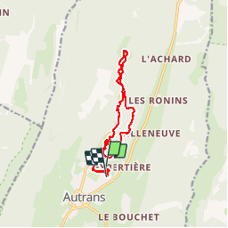

Length
13.7 km

Max alt
1313 m

Uphill gradient
296 m
Km-Effort
17.7 km

Min alt
1067 m

Downhill gradient
314 m
Boucle
No
Creation date :
2014-12-10 00:00:00.0
Updated on :
2014-12-10 00:00:00.0
3h04
Difficulty : Medium

FREE GPS app for hiking
 SityTrail
IGN / Geographical institutes
SityTrail Plus
The world is yours!
About
Trail Winter sports of 13.7 km to be discovered at Auvergne-Rhône-Alpes, Isère, Autrans-Méaudre en Vercors. This trail is proposed by mouss65.
Description
ski fond
Positioning
Country:
France
Region :
Auvergne-Rhône-Alpes
Department/Province :
Isère
Municipality :
Autrans-Méaudre en Vercors
Location:
Autrans
Start:(Dec)
Start:(UTM)
700547 ; 5006510 (31T) N.
Comments